Tuesday, December 10, 2013

November 2013

November was another good month. I continued to test my post-op knee and it feels great. Next month I’ll try some longer runs. High points of the month included running the Batona Trail leg 3 and returning to the Mount Misery Trail on Sunday mornings. I’ve been running the Cranberry Trail Wednesday nights for 6 weeks now. One night I forgot my head lamp but rather than make excuses I ran anyways, shadowing close behind Jim Pate and Trail Dog Danny.

Sunday, November 24th I ran the Batona Trail leg 3 with roughly 30 members of the Pineland Striders. This section covers 12.5 miles of pine and oak forests and numerous cedar swamps from Carranza Memorial in Tabernacle to Batsto Village in Wharton State Forest. This section of trail is one of my favourites as it never crosses a paved or travelled roadway, its complete wilderness. Temperatures hovered just under 30 degrees with a constant wind chilling the air. Jim’s warm glow-wine at the end was much appreciated. Five crazies ran an out-and-back for a cold 25 miles. Hopefully I can join them soon.


The other Sundays I joined Jim, Dee, and Trail Dog Danny on another of my favorite trails, the Mount Misery white trail. We saw flocks of beautiful snow geese in the cranberry bogs resting from their long migratory flight, and dog sled teams practicing with their wheeled-sleds. Thanks to Jim we had plenty of deer jerky at our water stop! Wintergreen berries were ripe for the picking so I stopped on the way home and picked a bag full. They are great to eat raw or soak the leaves into a minty tea.


Friday, December 6, 2013

October 2013


October was a good month with lots of short runs in New Jersey with my dog, Sparta. He finally behaves well enough to take him off his leash. He loves when we run in Whites Bog because he can take mid-run swims and soak me when he comes out. I worked on stretching also with yoga 2-3 times per week. High points of the month included running a couple legs of the 53 mile Batona Trail and restarting our Wednesday night Cranberry Trail runs.

 Sunday, October 20 I ran the Batona Trail leg 2 with roughly 30 members of the Pineland Striders. This section covers 13.5 miles from Pakim Pond, Brendan T. Byrne State Forest, traversing around the village of Chatsworth, passes over Apple Pie Hill and finishes at the Carranza Memorial south of Tabernacle in Wharton State Forest.  This section is beautiful and thanks to a reroute last year, now includes a technical section of narrow foot bridges through a cedar swamp and much to my liking some mud! Temperatures were 26 degree at the start and 30 at the finish with a constant cold wind all morning. We enjoyed warm wine and deer jerky at the finish thanks to Jim Pate and Trail Dog Danny. Carranza Memorial is a 12 foot Aztec design monument on the crash site of Captain Emilio Carranza, a Mexican goodwill pilot whose plane crashed July 13, 1928 while returning to Mexico.
Carranza Memorial
Pakim Pond


Sunday, October 27 I ran the Batona Trail leg 1 with Jeremy Helm, Mike Bialecki, and Sean Toohey. Leg 1 covers 8+ miles of rolling hills, through hardwood forest and cedar swamp from Ongs Hat to Pakim Pond in Brendan T. Byrne State Forest. While Sean and I called it a day, Jeremy and Mike continued on including leg 2 as well totaling roughly 22 miles. The temperature was a comfortable 35 degrees at the start with no wind, a great morning to run! 
Wednesday night trail runs are back! After my long break due to knee surgery, I finally started running my usual Wednesday night Cranberry Trail runs. It’s a mostly flat combination of single track and hard-packed dirt road with very few roots. Head lamps are a must this time of year as we start at 6:30 pm at the Brendan T. Byrne State Forest welcome center, run to Pakim Pond and back. Choices include a 2.3 mile short loop, 6 mile Cranberry Trail (actual), and 7.2 mile Cranberry Trail (extended).
 

Saturday, October 12, 2013

Albania 24Aug-14Sep13


My 5th trip to the Republic of Albania was definitely my favorite. This was the first time I have been there in warm weather; it’s always been winter on my previous visits. I spent a lot of time with old friends and made some new ones. The food was fantastic like always as everything is fresh, no preservatives there. The funniest thing that happened was on the third night I was eating at a Mexican restaurant, in Albania, in August, listening to American Christmas music. You just can’t make that up! 
 
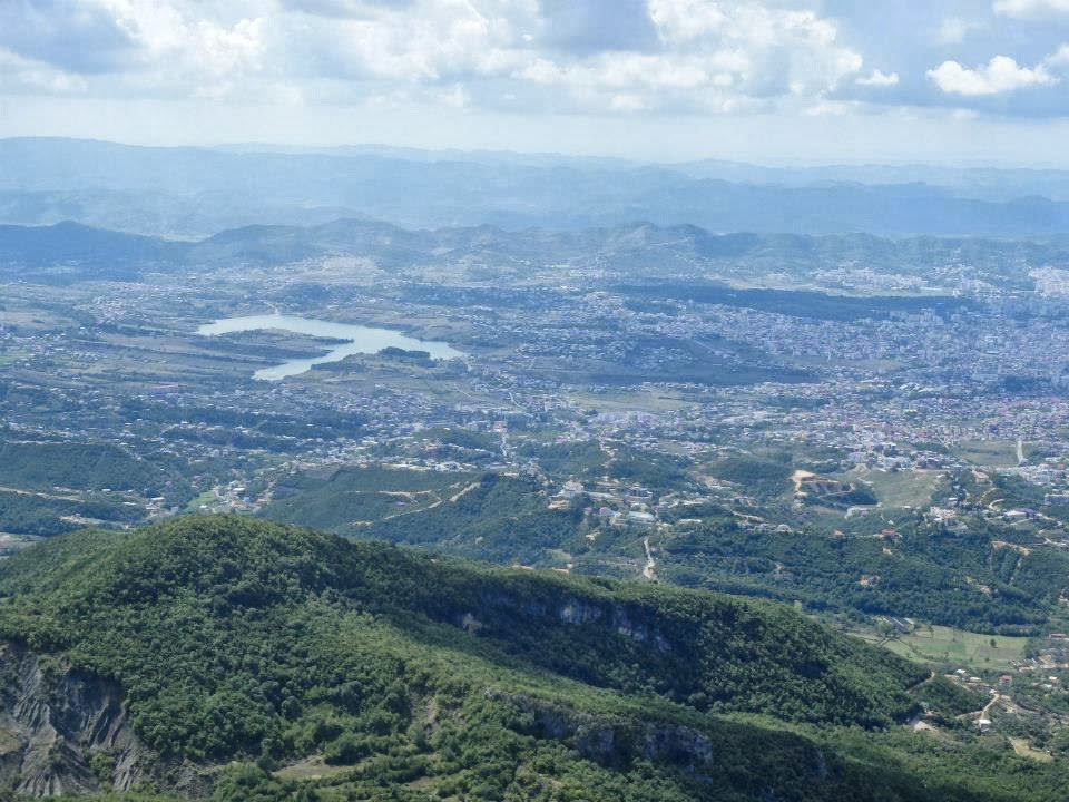
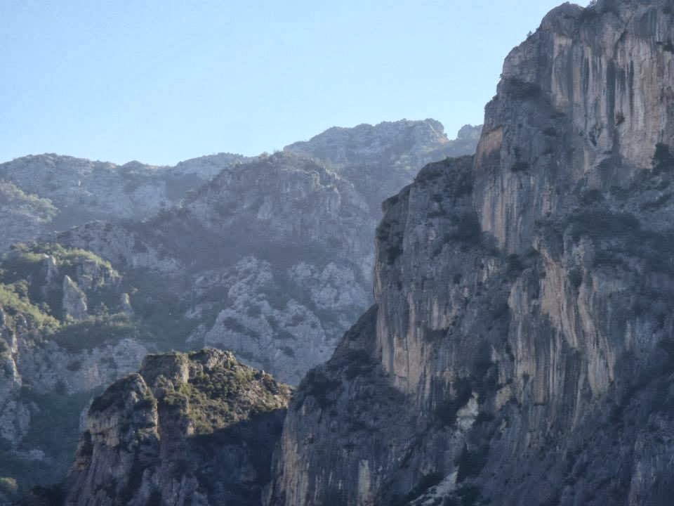
I had the opportunity to hike a few beautiful mountains: Maja e Gamtit (4131 feet), Maja e Brarit (4072 feet), and Maja e Dajtit (5292 feet).  Maja e Dajtit offers panoramic views of the capital city, Tirana. I saw the ruins of Shen Mari (St. Mary's Church) in the village of Shemine on the way up. On the Dajti Plateau, I visited the ruins of the Ish Kampi i PionerĂ«ve (Former Military Youth Camp) used during Communist times. A little further south I met the owners of the Foresta Bar, Hotel, and Restaurant. Using my limited Albanian language and hand signals, I was able to communicate with the elderly couple who led me to the trail head that leads to both peaks. The trail starts behind their home, climbs approximately 1000 feet and then splits in two toward each peak. After hiking around the area, I spent a couple hours enjoying some local beers (Korca) and fresh berries from behind their house.
 
I also visited the beautiful Kalaja e Rozafas in Shkodra District, Northwest Albania near the Montenegro border. Rozafa Castle dates back to antiquity. It was built by the Illyrians, and eventually captured by Romans in 167 BC. The only bad thing was that my sunglasses fell off my head when I leaned over the castle wall and was hit by a strong gust of wind blowing up the steep hill. The good thing is it gave me a reason to run up the steep face to find them. Mission accomplished, not only did I find my glasses but I found someone else’s too which I gave to my friend Dashi. The castle offers beautiful views of Liqeni I Shkodres (Lake Shkodra), the Buna River valley, and Hxamia e Plumbit (Lead Mosque) built in the early 1700s that now sits unused and at times underwater during flood season. After visiting the city of Shkodra, we had a great lunch in the village of Shiroke where we ate Krap (a type of carp only found in this lake) and buke misri (traditional corn bread slow-baked like a cake) along with more local beer and wines.
View of Tirana from Maja e Dajtit.
Ish Kampi i Pionereve (former Communist Military Youth Camp).
Foresta bar, hotel, and restaurant. Trailhead to the two peaks is located behind this building.
Maja e Brarit (4072 feet).


Maja e Brarit.
Kalaja e Rozafas (Rozafa Castle, Shkodra District).
Kalaja e Rozafas
Kalaja e Rozafas


Trail up Maja e Brarit.
Ruins of Shen Mari (St. Mary's Church in village of Shermine).
 
Maja e Gamtit (4131 feet).
 
My Merrill Trailgloves at Kalaja e Rozafas.
 
Lunch in Shiroke just south of Montenegro border.


Monday, August 5, 2013

Fall Mountain 03 Aug 2013


After months of knee pain followed by surgery, I finally used my newest pair of Inov-8 Bare Grip 200s last weekend. Now they look just like my old pair, muddy! I love these shoes. They have superior grip and with no midsole and zero drop these shoes offer amazing feel for the trail. This past weekend I returned to my roots in Vermont. As a teen, a couple times each week I’d run from my house in Bellows Falls, Vermont to the top of Fall Mountain ( Mount Kilburn)located across the Connecticut River  in North Walpole, New Hampshire. I would hang out there for hours eating my peanut butter and onion sandwiches and watching the hawks float effortless below. The mountain’s 1120 feet of elevation is not large but the old carriage road has sections exceeding 30 degree inclines to raise your heart rate along with a seemingly endless supply of loose rocks. Inclines of 70-80 degrees await the adventurous who assault up the face. There are lots of single track trails, logging roads, and power lines traversing the ridge but the most popular spot is the Table Rock overlook. It offers close to 180 degree views of the Connecticut River valley and my home town of Bellows Falls. I’ve been disappointed for so long not being able to run but that all changed on this day. It felt awesome to be jogging and to be back on the mountain. I have renewed optimism.  I can’t wait for my next run!


Thursday, August 1, 2013

Knee Surgery and Recovery


On June 12, 2013 I had surgery to remove complex posterior horn tear of the medial meniscus and pathologic suprapatellar synovial plica of the left knee. The procedure went smoothly and I was out of the clinic in about 2 hours. The worse thing about the recovery was sitting around my house for 2 weeks with nothing to do. I caught up on some reading and watched a lot of movies but mostly sat thinking about being out on the trails.
After that I started slowly walking 1 mile per day with my Bledsoe Z12 OA knee brace. Then the next week I increased my walks to 2 miles, then to 3 miles, and finally 4 miles every day during week 6. This week I started adding some short slow jogging in the middle of my walks and experienced only slight pain. Tonight was a great night.  I jogged about a mile during my walk. The heavy rain created mud everywhere at Whites Bog. It was slippery, sloppy, and felt so good. Next week I’ll attempt to jog further.
Week 1 Post-op


Bouncing Buns 7K "Clothing Optional" Trail Race


The 3rd annual Bouncing Buns 7K trail race was held at the “Clothing Optional” Sunny Rest Resort in Palmerton, PA on Saturday, June 23, 2012. The race continues to grow each year. There were 46 finishers in 2010, 105 in 2011, and 145 finishing this year. It supports the Cancer Society and is a great way to enjoy nature. The race is managed and timed by www.pretzelcitysports.com. It’s run on well marked and well groomed trails entirely within the resorts 190 acres. The course starts and finishes in front of the owner, Myra Mesher’s house. It does a short loop on the road, and then makes its way into the woods at the top of the only steep hill. It is approximately 75% shaded on single and double track trails. There are a few spots where the rhododendron bushes form long tunnels the runners pass through. The last mile winds its way around the camping area with plenty of spectators cheering on the runners as they bounce along.

With temperatures in the 90s, the mid-way water station was well appreciated and participants passed it in each direction. There was also a gentleman spraying runners with his hose cool us down prior to the last hill sprint to the finish. Approximately 80% of this years participants were partially or completely nude as were the spectators. Participants came from 9 states, as well as Canada and Brazil. Ages ranged from 19 to 68 years young with a ratio of 30% female/70% male.

 
            The resort offers motel rooms, tent, camper, and RV sites. There are a number of cabins available for seasonal stays for members as well as a few year-round homes on site. Race participants and their guests have full use of the facilities on race day. While the race was conducted on the hill, the awards were handed out beside the pool. While the resort is “clothing optional”, no swim wear is allowed in the pool or hot. Most participants stayed for the BBQ after the awards and listened to the live music.

             Resort amenities include nature trails, heated swimming pool, heated conversation pool, sand volleyball, bar and restaurant next to the pool, couples massage, fitness room, hot tub, night club, tennis courts, yoga classes, basketball, billiards, ping pong, children’s playground, and store. Sunny Rest Resort opened in 1945 and is a family-friendly resort. They have events every weekend from mid-May to mid-September. Events include such things as Murder Mystery and Dinner Show, volleyball (sand and water) and tennis tournaments, Beer Festival, dive-in movies at the pool, live and DJ music, poolside “Grillin’ and Chillin’ BBQ, karaoke and open mike nights, costume and theme nights in the night club, and much more. For more information on events, rates, and directions visit them at www.sunnyrest.com. Until next years race, take it off and go for a run.

Friday, July 26, 2013

My Single Day Run around New England (aka. 30 miles, 6 states, 1 day) 20Oct93


            When I awoke October 20, 1993 I knew it was going to be a special day. Unlike the normal work Wednesday this day I had a goal. I was going to run at least 5 miles in all 6 New England states in 1 day. Since I had decided the evening before to do this it would prove to be a solo adventure. While I enjoy running alone I wasn’t looking forward to all the driving it would require. Other than the loop I ran from home all others would have to be run as out-and-backs. I would pick a landmark and park my car at least 2.5 miles away.

Leg 1: Keene, New Hampshire. I woke up at 4am, got dressed and re-checked the bag I had packed the night before. At 4:30am I headed out to begin run number one. Other than the skunk I came face-to-face with the run went quick and uneventful. Luckily the skunk didn’t mind sharing the road with me as we greeted each other with a quick raise of the head and continued on our own quests, mine being 6 states and his being the neighbor’s trash barrel. When done I showered, ate some breakfast and headed for Vermont.

Leg 2: Brattleboro, Vermont. This run would be on familiar roads. About 6:45am I parked my car at the entrance to the Brattleboro Country Club Golf Course on Upper Dummerston Road. This was also the site of the Red Clover Rover Running Club’s annual Turkey Trot. The road rolls gently past farms and single family country houses. It’s a peaceful run any time of the day. The only memorable thing besides the rain was seeing fellow Red Clover Rover Hank Lange running the other way. Hank Lange is an Ironman triathlete, triathlon coach and personal health, wellness and fitness coach. Unlike the quick raise of the head exchanged with the skunk earlier, we greeted each other verbally as he flew past me. Knowing Hank back then, he was probably completing 30 miles before his breakfast while my 30 miles was going to take all day. With two states done, I ate a snack and then drove south on Interstate 91 to Massachusetts for round three.

Leg 3: South Hatfield, Massachusetts. At 8:45am I parked on the side of the road and used the huge, newly built C&S Wholesale Grocer’s warehouse as my turnaround point. While the rain I experienced earlier had died down to a light drizzle, the wind was picking up some but not enough to make a difference. The run went smooth and I was very happy to be half done. I changed into dry cloths in my car and continued south on I-91 into Connecticut.

Leg 4: Stafford Springs, Connecticut. I exited I-91 at exit 47 and headed east on Route 190 passing through Hazardville (not associated with the Dukes of Hazard) and Somers before finding my next landmark. I drove east on Route 190 (Buckley Hwy) and parked my car in the edge of someone’s dirt driveway. It was a beautiful run down into town and then back up to my car.  I did experience some minor knee pain but nothing to worry about. I changed into more dry cloths and ate a couple peanut butter and onion sandwiches and headed for Rhode Island. As I drove east I was glad I had brought the sandwiches because the onion smell was covering up the wet dog smell coming from the backseat that I realized was actually my pile of sweaty cloths and shoes.

Leg 5: Smithfield, Rhode Island. I drove east on Rte 190 and 197 to Webster, MA where I stopped for a huge juicy cheese burger and fries. Then I drove south on I-395 past beautiful Lake Chaubunagungmaug, or as I called it Lake What-the-F???. Then I turned east again along Rte 44 into Smithfield, Rhode Island home of the Bryant University Bulldogs. My run seemed to fly by as I realized I only had one more state to finish. I hesitate to say the road was hilly since the maximum elevation in RI is a mighty 811feet so I will call it gently rolling non-level. It was a great run.

Leg 6: Kittery. Maine. Now came the longest drive of the day. My plan to cruise up I-295 and then I-95 into Kittery proved to have one slight drawback, Boston home to my beloved Red Sox, Bruins, Celtics, and Patriots I was making great time until I hit the traffic jam from hell. It took over 4 hours to drive just 120 miles. By the time I reached Kittery my knees had swelled and my legs were tighter than a pair of daisy dukes. I measured 2.6 miles from the Kittery Circle to Fort McClary, which was built in 1808 as a coastal defensive fortification. I struggled the first couple miles as my legs felt like they weighed a ton. It was the hilliest of my runs but when I turned around at the circle all the pain went away. I attacked the final hills back up to the fort. I arrived back to my car just before 6:30 pm and cracked open a warm beer to celebrate. My quest had taken me over 14 hours, thanks to the Boston traffic but it was finally over, 30+ miles, 6 states, 1 day. My run around New England was complete.

The inspiration to do this came from my high school running coach. He ran 10 miles in all six New England states in one day. Luckly his wife helped drive so he could rest between runs.
 

Thursday, July 25, 2013

Border-to-Border 20 Miler 19Feb94


The Border-to-Border 20 Miler was a point-to-point race run in three states (Maine, New Hampshire, and Massachusetts), through seven towns, all in one race. Starting in the hills of Kittery, Maine runners passed through the New Hampshire villages of Portsmouth, Rye, North Hampton, Hampton and Seabrook and finished in Salisbury, Massachusetts.

The February 19, 1994 race was a memorable one for many reasons but mostly due to the incredibly warm weather on race day. Northern New England had been experiencing sub-freezing temperatures and severe wind-chills for a week leading up to race day. Miraculously, that all changed, as we were blessed with sunny mid-thirties temperatures and no wind. It was a perfect day to run 20 miles. The warm weather brought out twice as many runners as were expected which caused a logistical nightmare for the race staff as they shuttled runners from the finish area in Salisbury, MA to the start point in Kittery, ME. The extra bus trips delayed the race about an hour. Then as we lined up to begin the race, word came in that a draw-bridge near the start had gotten stuck open which added another 30 minute delay.  Once fixed the race director got us re-set and the gun went off. The course passed through historic districts, wooded areas, and salt-water marshes. We also passed numerous mansions, small cottages, surf and t-shirt shops, and finished at a crab shack. It was a true coastal experience. Instead of the usual race t-shirt, we all received ski hats which were quickly put to good use as the temperature dipped below freezing once again by the next morning.   

This race is now known as the Eastern States 20 Mile and the course remains roughly the same except for deleting the Kittery, ME portion. It now includes 2 states and six towns. If you are looking for a fast late-winter 20 miler this race is worth checking out. Next year’s race day will be March 30, 2014. The official race site is: http://www.easternstates20mile.com/


Wednesday, July 24, 2013

A long 3 miles


Early on I realized that while I lacked the speed of some of my teammates, I could run longer than most of them. While high school track and cross country workouts were very structured, I have always taken a flexible approach to my running. I run how I feel. Some long runs get cut short while some short runs get extended depending upon how I am feeling. I mention this because my friend Tim and I were reminiscing last week how thirty years ago we went out to run an easy 3 miles and ended up running 17. Like Forest Gump...we just kept running. That was the first time I can remember feeling the infamous “runners high”. I’ve been searching for it ever since.