
(My Dirtbag home for the week, including Christmas lights)
Day 1:
With my Everest Base Camp trek rapidly approaching, I
travelled out to Colorado for some elevation training. As hard to believe as it
might be, I don’t think living at 62’ above sea level adequately prepares one
for hiking in the Nepal highlands. So off to Colorado Springs I went. I flew
out to Denver Airport and picked up a rental SUV that would serve as my Dirtbag
home on wheels for the week. Upon arriving in Colorado Springs, I drove to
Bill’s Old-World Pizza on South 8th Street for a Colorado Springs/ Kimchi
Hashrun. Since all the Colorado Hash House Harrier kennels (groups) were
attending a weekend-long campout the run turned out to be just me. That made
searching for the “true trail” marks a bit challenging but not impossible. It
took me about an hour to cover the 3-mile trail due to several “false marks”
and heavy traffic but much to my delight it led me to the N3 Taphouse, an early
1900s fire station renovated into a wonderful restaurant with awesome food,
friendly staff and a huge selection of beers. I ate some awesome chicken tacos and washed them down with Guinness (of course). I spent the rest of the evening
visiting my daughter Egypt and her family before heading into the mountains to
car-camp.

(Yum!)
Day 2:
The next morning, I drove to Upper Gold Camp Parking Lot,
enjoyed a couple peanut butter and onion sandwiches for breakfast and packed my
daypack. I ran/hiked High Drive for about a mile until I reached the trailhead
for the Captain Jacks Trail. Not realizing there was an actual trail nearby, I
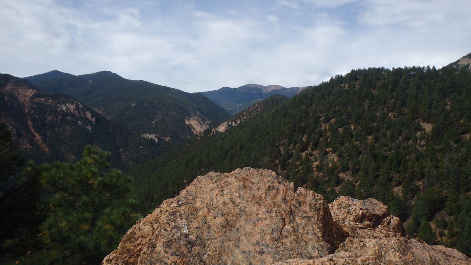
scrambled my way up to the summit of May’s Peak (8283’) on my right. From there
I had almost 360-degree views of Colorado Springs to the east as well as beautiful
mountains to the north, west and south. While there I met 2 couples from
California and signed the registry that was hidden in an ammo can under a pine
tree. After taking a few pictures I headed down the actual trail back to the
Captain Jacks trailhead. I followed the trail west up to the boulder-covered
Buckhorn Peak (8380’). The coolest part of this peak is that one of the largest
boulders rests on several smaller ones forming a cave large enough to camp in.
I continued along the same trail until reaching a 4-way intersection. Since I had
drank all my water, I turned left and returned to the parking lot. Back at the
car, I ate another peanut butter & onion sandwich, refilled my water
bottles and headed out along the Gold Camp Road (GCR), a former train line. Other
than a short section that bypasses the now gated Tunnel #3 which is partially
collapsed, GCR has a steady incline as it winds its way south toward Cripple
Creek. I passed through Tunnels #4 & 5 and under St. Peter’s Dome (on my
list of future climbs). Once again, I didn’t plan properly with my water for
such a hot day, so I turned around at mile 7 and headed back to the car. In
all, I ran/hiked about 20 miles for the day, so I drove back down into town for
dinner with my daughter. I drove back up
to the Upper Gold Camp parking lot around midnight and retired to my sleeping
bag for the night.

(Buckhorn Peak on left; May's Peak on right)

(Colorado Springs)

(May's Peak)

(Buckhorn Peak)

(Logs used to reach the peak)
(The view west)

(Under the peak)

(On the peak)
Day 3:
I woke up to another beautiful Colorado morning. I did some
yoga beside the car and then made some breakfast before heading back out GCR.
Todays goal was to follow GCR out to the Eagles Nest overview point; but since
I was unsure exactly how far away it was, I carried a third bottle of water. Like
the previous day, I stopped to take pictures of Tunnels #4 & 5 as well as
St. Peter’s Dome towering over me before continuing. Eventually, around mile 8
or 9, GCR joins Old Stage Road. At that point, the partially collapsed Tunnel
#6 is located just to the right. The cool thing is that, unlike Tunnel #3 which
is gated, Tunnel #6 is still passable. There’s a lot a debris inside, between
trash and stones that have fallen from the ceiling, so you will need a light if
you plan to explore this one. After checking out the tunnel, I continued up Old
Stage Road to the Eagle’s Nest parking lot. It was just shy of 10 miles from
where I had started. I climbed the boulders to the right and ate a snack there
while enjoying the views it offered. Bolted onto the upper boulder is a plaque
in memory of SPC John J. Cowen who had perished there September 2, 2007 from a
lightning strike. The return route felt awesome as it was 100% downhill with
the short detour over Tunnel #3 being the only exception. So, with another 20-mile
day in the books, I headed back down into town to my daughter’s house for
dinner and to play with my granddaughter.

(Tunnel #3)

(Tunnel #4)

(Tunnel #5)

(Tunnel #6)


(Top of the Eagles Nest)

(Watch out for rapidly changing weather)

(View from the Eagles Nest)
Day 4:
Upon waking up I went outside to pack the car. My plan for
the day was to hike up the Barr Trail from Manitou Springs to Pikes Peak and
then run back down. I looked across town toward the peak and, to my dismay, realized
it had snowed up there overnight. Since I didn’t have any cold-weather cloths
with me I had to quickly change my plan. I decided to drive up Pikes Peak instead
with my daughter and her family. That way I could still get some time over
14,000’ but not freeze getting there. The access road was steep, and the views
were amazing. By the time we arrived at the summit, most of the snow had melted
but it was still very cold. I didn’t feel any altitude symptom during the 3
hours I spent up there which was a good sign with my Mt Everest Base Camp trek
coming just 30 days later. Later that evening I linked up with a few runners
from the Colorado Kimchi Hash House Harriers for Tacos and beers.


Day 5:
I had planned to start hiking at 7am but I hit snooze
numerous times; eventually getting up after 9am. This delayed start would prove
to be detrimental to my day’s goals. I once again parked at Upper Gold Camp
parking lot and followed GCR south. The weather forecast called for
thunderstorms. The temperature was considerably cooler than the previous
mornings and a light rain was already falling by the time I headed out. Immediately
after the Tunnel #3 bypass, I turned west onto the St. Mary’s Falls Trail. The
trail follows upstream and eventually ends at the base of the falls.
Unfortunately, there was only a small stream of water falling over the cliff. To
the right of the falls and attached to a tree stump is a plaque in memory of
60-year old Eamon Murphy who fell to his death there May 24, 2008 after
solo-climbing Stove Mountain above the Falls. From the falls I scrambled up the
side of Stove Mountain until I merged onto the Mt Rosa Trail. The rain was
falling harder now as I crested Stove Mountain and headed south toward Mt Rosa.
A very dark cloud suddenly blew over the summit and instantly dropped down.
Without warning, there was a blinding light and deafening crack as the first
lightning bolt struck a tree close enough to me that I felt the concussion of the
shock wave. That was enough to force me to abort my Mt Rosa summit attempt. I
turned around and ran as fast as I could down the switchbacks. The storm cloud
seemed to chase me the entire 4 miles back to my car, throwing heavy rain and
hail at me the entire way. Luckily, I made it back safely without becoming
another casualty. After drying off in the back of the SUV, I enjoyed a couple
peanut butter & onion sandwiches; washed them down with warm Guinness and
waited for the rain to stop. Since it was my last full day there, I returned to
town and spent the day with my daughter. Even though I had cut my day short I
did log 8 miles and about 3,000 feet of gain. In all, I logged about 50 miles,
just over 9,000’ of gain, a couple peaks, 3 hours above 14,000, hung out with
friends, and met my newest granddaughter. It was a great week!


 \
\


(Here comes the thundercloud behind me)

(Just before the first lightning and hail chased me off the mountain)


